
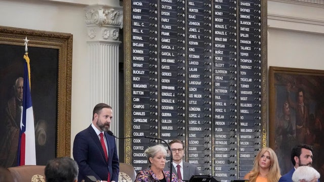
Durbin joins Texas Democrats to discuss threat redistricting fight reveals
Illinois Senator Dick Durbin joined Texas Democrats to warn that the redistricting fight in the Lone Star State is the first sign of a threat to the whole country.
Watch CBS News
Breaking Local News, First Alert Weather & I-Team Reports
Illinois Senator Dick Durbin joined Texas Democrats to warn that the redistricting fight in the Lone Star State is the first sign of a threat to the whole country.
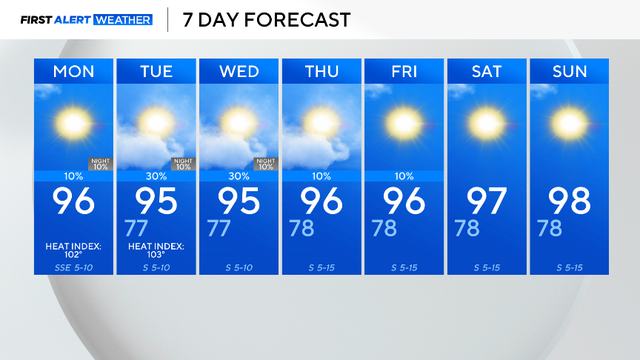
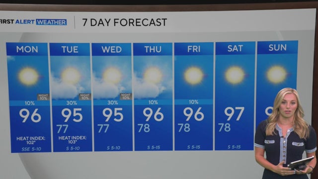
So far, 28% of this summer has been cooler than normal and this trend is likely to continue through the week.

Cheer stunts, fatherly wisdom, and an unshakable bond — that's what you'll find on Roland Pollard's Instagram feed.

Tropical Storm Erin could strengthen to become the Atlantic's first hurricane of the season.

Republican lawmakers in Texas have opened a new front in their efforts to crack down on abortion, this time with a bill that would enable lawsuits targeting the mailing of pills.

AOL said it will discontinue its dial-up service and "associated software" on Sept. 30.

At least five vehicles were involved, FWPD said.
On the fourth try, the Texas House failed to make quorum, with 96 lawmakers present.

Cocaine has been found hidden in banana shipments across the globe in recent months.


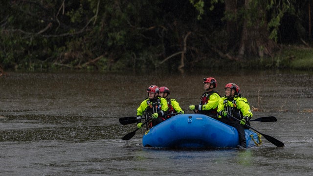
Several organizations are accepting donations for those impacted by the floods, as well as first responders and volunteers.
Former campers, who are now adults, share their memories from Camp Mystic and remember those who died in the devastating Hill Country flood on July 4.
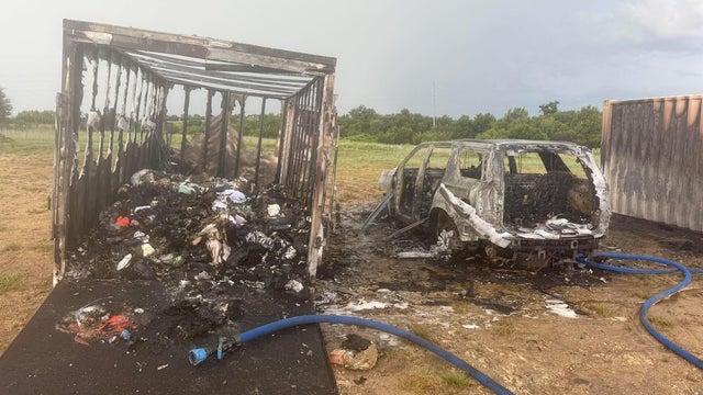
An act of nature has destroyed what was a kind gesture from a group of people in Parker County.

Texas officials have faced questions over their preparedness and the speed of their initial actions when flash flooding hit.

The public hearing will take place at Hill Country Youth Event Center at 9:30 a.m.
Cheer stunts, fatherly wisdom, and an unshakable bond — that's what you'll find on Roland Pollard's Instagram feed.
The circumstances surrounding Bevers' death have remained a mystery.

Abbott filed an emergency petition with the Texas Supreme Court to have Rep. Gene Wu, D-Houston, the Democratic Caucus Chair, removed from office.
So far, 28% of this summer has been cooler than normal and this trend is likely to continue through the week.

AOL said it will discontinue its dial-up service and "associated software" on Sept. 30. About 163,000 households had dial-up as of 2023, according to U.S. Census Bureau data.

As of Monday morning, some Texas Democrats were still in Illinois and were joined by Illinois Sen. Dick Durbin and other legislative leaders to discuss harm they say the state's plan for a mid-decade redistricting could have on the country.

It would be the first face-to-face meeting between Russian President Vladimir Putin and an American leader since former President Joe Biden met with Putin in June 2021.

One man is in custody and another has been hospitalized following a shooting Sunday evening at Collin College's student housing complex in Plano, police said.
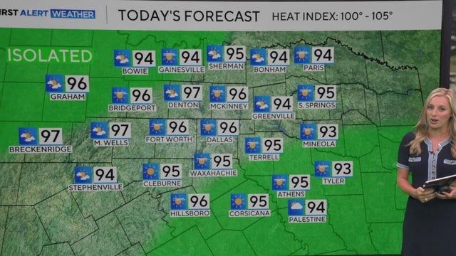
So far, 28% of this summer has been cooler than normal and this trend is likely to continue through the week.
So far, 28% of this summer has been cooler than normal and this trend is likely to continue through the week.
After a stretch of dry days, some North Texans could see some rainfall this week.
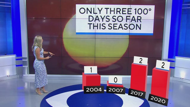
So far this summer, temperatures have been below-average. But the heat still remains dangerous as the indices peak into the triple-digits across the area.

For migrant children, who range in age from 3 to 17 years old and arrive in the U.S. without a guardian, applying for asylum can be a confusing obstacle.

SB 36 will create a division of Homeland Security within Texas's Department of Public Safety.

Two weeks ago, the Trump administration began carrying out its latest tactic aimed at fast-tracking deportations.

The detentions come on the heels of similar arrests earlier this week in immigration courts across the country.

Multiple sources have confirmed that at least a handful of people were arrested on the spot after their cases were dismissed in Dallas.

While illegal migrant crossings have dropped, immigration courts now have a historically high volume of cases

With the expansion of the 287(g) program, local and state officers will be able to enforce some immigration duties.
While the Trump administration says they're only targeting criminals for deportation, those words have done little to comfort some immigrants

A few weeks into his second term, President Donald Trump has issued dozens of executive orders.
Social media had a field day with the incident overnight and well into Sunday.

Shigetoshi Kotari and Hiromasa Urakawa, both 28, died after sustaining brain injuries during separate bouts on the same card at Tokyo's Korakuen Hall.
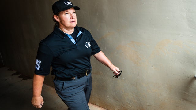
Jen Pawol has made history as the first female umpire to work a regular-season game in the major leagues.

Dallas was without rookie Paige Bueckers due to a back injury that required treatment when the teams met Tuesday in New York.
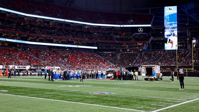
Detroit Lions safety Morice Norris Jr. is in stable condition after suffering a serious injury during Friday night's preseason game against the Atlanta Falcons, the team said.
Eat See Play: Sponsored by Metroplex Cadillac Dealers

Eat See Play: Sponsored by Metroplex Cadillac Dealers

Eat See Play: Sponsored by Metroplex Cadillac Dealers

Eat See Play: Sponsored by Metroplex Cadillac Dealers

Eat See Play: Sponsored by Metroplex Cadillac Dealers

Eat See Play: Sponsored by Metroplex Cadillac Dealers

Eat See Play: Sponsored by Metroplex Cadillac Dealers

Eat See Play: Sponsored by Metroplex Cadillac Dealers

Eat See Play: Sponsored by Metroplex Cadillac Dealers
Illinois Senator Dick Durbin joined Texas Democrats to warn that the redistricting fight in the Lone Star State is the first sign of a threat to the whole country.
So far, 28% of this summer has been cooler than normal and this trend is likely to continue through the week.
Cheer stunts, fatherly wisdom, and an unshakable bond — that's what you'll find on Roland Pollard's Instagram feed.
Tropical Storm Erin could strengthen to become the Atlantic's first hurricane of the season.
Republican lawmakers in Texas have opened a new front in their efforts to crack down on abortion, this time with a bill that would enable lawsuits targeting the mailing of pills.
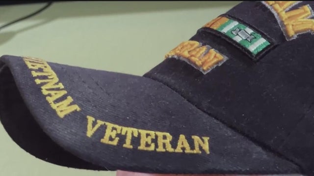
The VA in North Texas is using a new algorithm to calculate the hours of in-home care that veterans receive.

The nonprofit employs men and women who have had past run-ins with the law to work as mentors for at-risk teens and young men.

Sidhartha "Sammy" Mukherjee and his wife Sunita became known for their Bollywood-style performances, became local celebrities, hosting parties and headlining music and cultural events.

On Thursday, the Texas House and Senate announced the creation of committees on disaster preparedness and flooding.
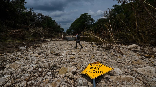
In what experts call "Flash Flood Alley," the terrain reacts quickly to rainfall steep slopes, rocky ground, and narrow riverbeds leave little time for warning.
Illinois Senator Dick Durbin joined Texas Democrats to warn that the redistricting fight in the Lone Star State is the first sign of a threat to the whole country.
Republican lawmakers in Texas have opened a new front in their efforts to crack down on abortion, this time with a bill that would enable lawsuits targeting the mailing of pills.
On the fourth try, the Texas House failed to make quorum, with 96 lawmakers present.
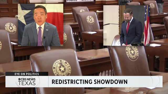
The Texas redistricting battle is intensifying as House Democrats flee the state to block a Republican-drawn map that could flip five congressional seats. The Texas House once again failed to reach quorum on Friday, and a flurry of lawsuits has been filed.

President Trump is hinting at further federal police action in D.C., teasing a press conference on Monday aimed at "ending the Crime, Murder, and Death."

At Fort Worth ISD's North Side High School, the sounds of an American sport on the field meet mariachi music in the stands.

With new foods, such as the "Drowning Taquitos" and the "Beso de Angel," Tony's Taco Shop owners say they don't take their success for granted.

Latinas in Tech DFW started back up last year after the pandemic. They have lots of opportunities for Latinas to network, connect, and learn new skills.
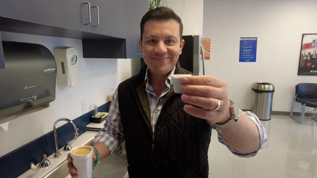
Anchor Ken Molestina shows us how he makes his Cuban coffee for the CBS News Texas newsroom.
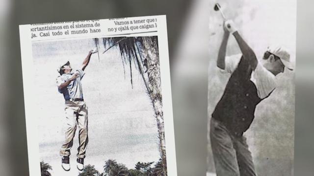
Del Olmo, who has played golf his entire life, recalls how rare the sport was for people like him growing up in Mexico City.

Less than two days after Delta Air Lines offered $30,000 to each passenger on board the flight that crashed and flipped in Toronto on Monday afternoon, the company is facing its first two lawsuits in the incident — and they likely won't be the last.

Texas Agricultural Commissioner Sid Miller is calling for a statewide ban on non-water additives, such as fluoride, in the public water system.

Last year, over 16 million vehicles drove on North Texas toll roads without paying, accumulating more than $69 million in unpaid tolls.

Activists are calling for a nationwide boycott of Target stores following the company's decision to roll back its diversity, equity and inclusion initiatives.

Discount store chain Target says it's joining rival Walmart and a number of other prominent American brands in scaling back corporate diversity, equity and inclusion initiatives.

Instagram rolled out a new Map feature that lets users see their friends' locations in real time. Here's why privacy experts are concerned.
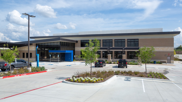
For the first time in more than 30 years, a Fort Worth community long considered a "health care desert" now has nearby access to basic medical care.
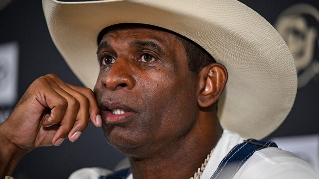
Head Colorado Buffaloes football Coach Deion "Coach Prime" Sanders revealed his bladder cancer diagnosis for the first time on Monday morning.

Pepsi hops on another nutritional bandwagon as more consumers opt for prebiotic beverages.

Many Southeast, Southern and West Coast states are likely seeing an increase in COVID cases.

A truck had smashed through the front of Bruno's Place, destroying much of the inside.

Kroger said it intentionally decreased prices, but some customers said the financial drop at the register went in a different direction.
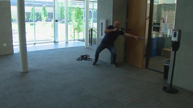
Could the solution to school shootings be drone first responders? An Austin-based tech company thinks so and is testing them at a private high school in Aurora.

Located off the Guadalupe River in Historic Old Ingram Loop, the shop was once filled floor to with lighting, decor and trinkets.

They were already concerned about tariffs, but construction businesses in North Texas said they have new fears with the president's immigration crackdown.
Social media had a field day with the incident overnight and well into Sunday.
Shigetoshi Kotari and Hiromasa Urakawa, both 28, died after sustaining brain injuries during separate bouts on the same card at Tokyo's Korakuen Hall.
Jen Pawol has made history as the first female umpire to work a regular-season game in the major leagues.
Dallas was without rookie Paige Bueckers due to a back injury that required treatment when the teams met Tuesday in New York.
Detroit Lions safety Morice Norris Jr. is in stable condition after suffering a serious injury during Friday night's preseason game against the Atlanta Falcons, the team said.

Bobby Whitlock, the musician who co-founded Derek and the Dominos with Eric Clapton, has died, according to his manager. He was 77.

An ICE spokesperson ICE Assistant Secretary confirmed that Dean Cain will be sworn in as an honorary ICE officer in the coming month.

Brandon Blackstock battled cancer for more than three years, his family said.

The 2.73-mile course will weave through Arlington's core sports and entertainment district.
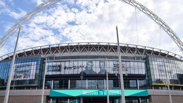
Oasis said that its members are "shocked and saddened" after a man fell to his death during a concert by the band at London's Wembley Stadium.
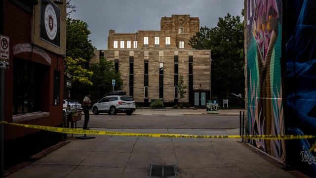
A suspect was taken into custody after an attack on Pearl Street Mall in Boulder on June 1 in which there were 15 people and a dog who were victims. The suspect threw Molotov cocktails that burned some of the victims, who were part of a march for Israeli hostages.

The Neonatal Intensive Care Unit babies at Texas Health locations across North Texas celebrated Valentine's Day.

As Anthony Davis prepared for his debut game at the AAC, Dallas Mavericks fans took to the arena to protest the controversial trade.

A look back at the esteemed personalities who've left us this year, who'd touched us with their innovation, creativity and humanity.

CBS News Texas viewers got out and enjoyed the snow day on Thursday and send us all of their best photos. Take a look.